e7odie
  • Home
  • Blog
  • Trivia
    • Trivia 1.0
    • Trivia 2.0
    • Trivia 3.0
    • Trivia 4.0 (coming soon)
    • Trivia 5.0 (coming soon)
  • Game

Namesake of All United States' Counties

8/23/2016

0 Comments

 
​The idea for this one came after I saw this semi-related map about the language of origin of every county's name. After tediously going through each "List of counties in [State]" Wikipedia pages, I finally finished this time-consuming project to see what every county was named after.

First off, there's a decent grain of salt to be taken with this map. While most counties were pretty simply and straightforward, a lot of them were far more complicated than that. The two most complicated categories were
  • counties named after two things - so, for example, a county named after a geographical feature (e.g., mountain or river) that was in turn named for a person or a native American tribe
  • counties named after people with long titles, perhaps of the format [First Name] [Last Name], [Title] of [Place] in which the county name is just the title or place - 
I admit that when I started this, I spent more time delving into these outlier examples to determine what I should color the respective county; but as time went on this got more frustrating as the extra research rarely resulted in a clear answer. As such, several counties are striped for multiple namesakes. Also, speaking of striped counties, some of them are striped because the etymology itself is disputed. Alaska's Nome Census Area for example, has three potential stories behind its name, each of which is a different color in my key of 6 categories.

Anyway, without further ado:
Picture

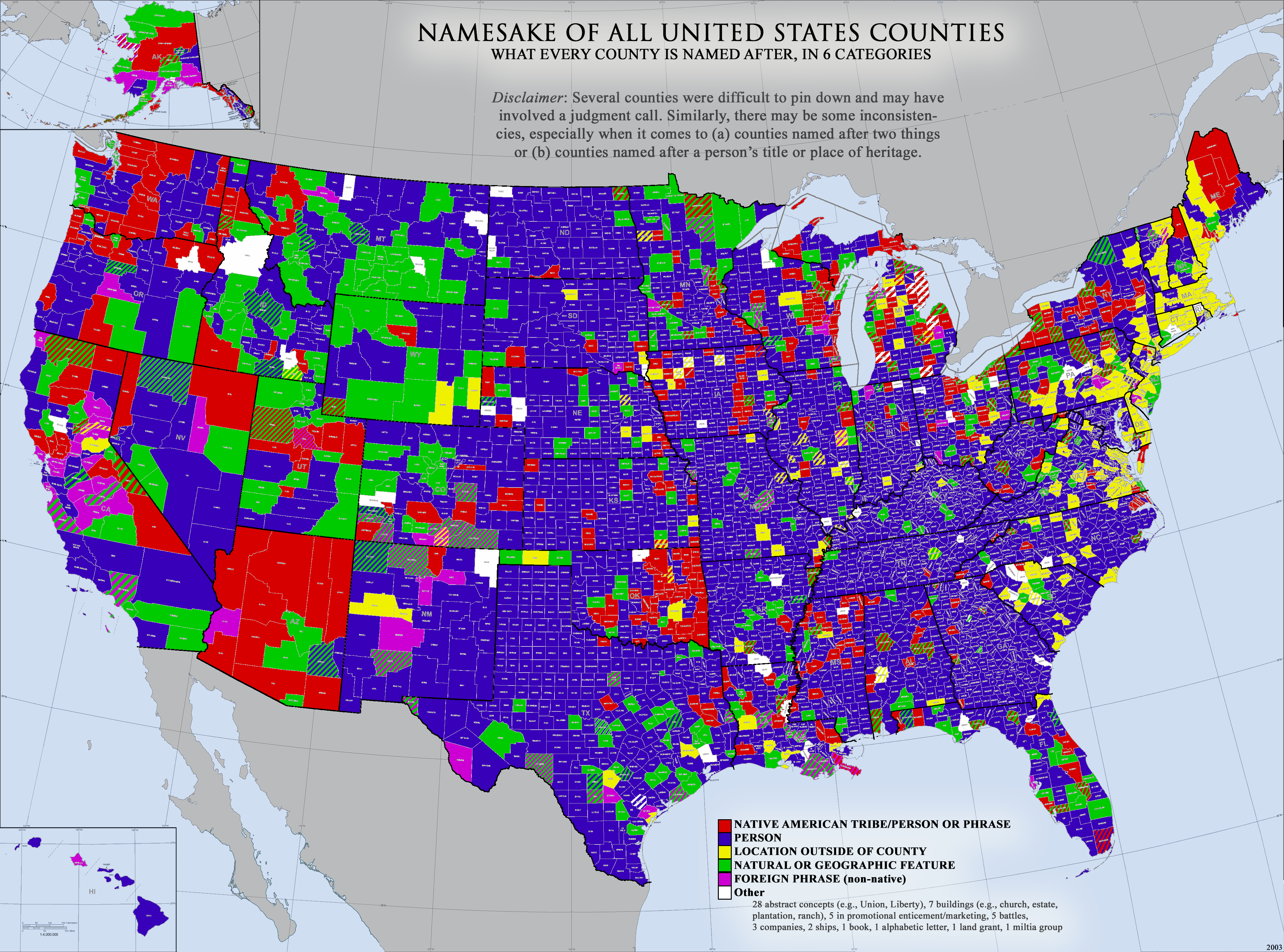
Not too many not-already-obvious trends to really analyze or comment about, here.
  • Lots of Spanish, Native American, and natural oriented names in the west
  • Lots of counties named after elsewhere locations in the northeast (thanks, uncreative colonists)
  • North Dakota, Missouri, Indiana, Kentucky, Tennessee, and Georgia have some of the highest percentages of being named after a person (Delaware and Hawaii also have high percentages of a single category, but, ya know, having fewer than 6 counties helps)
  • Somewhat surprisingly (to me, at least), there are three counties in Iowa that were named after battles in the Mexican-American War

Lastly, just because I feel like this will be a common question when you're looking at all the counties in the US, here's the top of the list (15+) of the most common county names (just taken straight from a separate Wikipedia page):
  1. Washington County (31)
  2. Jefferson County (26)
  3. Franklin County (24)
  4. Jackson County (24)
  5. Lincoln County (24)
  6. Madison County (20)
  7. Clay County (18)
  8. Montgomery County (18)
  9. Union County (18)
  10. Marion County (17)
  11. Monroe County (17)
  12. Wayne County (16)
  13. Grant County (15)​
0 Comments

Dividing the world into 'n' regions (from n=1 to n=22)

8/22/2016

0 Comments

 
So this started off as a search for something similar and when I couldn't find it, I made one of my own. I thought I had previously seen a series of maps that divided the world into various numbers of regions. What if you had to group the entire world into only 2 sections; where do you draw the line? How about 5 regions? And so on and so on. Perhaps I was just making things up, as I couldn't find said mythical post. So here's mine:

Here's a link to an imgur album of the same images: ​http://imgur.com/a/DflY7
0 Comments

The United States of Europe

9/23/2015

0 Comments

 
As of now, this is incomplete; but I to intend to continue working on it and, with the assistance of others who know more about the left-out countries than I do, will fill out the rest eventually. Currently, this is a map I made based off the comic of another Redditor, who I later collaborated with to fill it out slightly more. The idea was simply to draw parallels between US states and European countries. Grounds for these comparisons could be anything - from economic GDP to cultural problems, from common histories to geographic similarities. Most have been given speech bubbles to help explain what exactly my (or the original comic maker's) thought process was. I was really tempted to add Georgia as Georgia.


If you don't know your European countries or your US state flags, see below to see all the pairings.
Picture
For clarity's sake, here's all the country/state pairings: Iceland/Hawaii, UK/Texas, Ireland/Idaho, Portugal/Oregon, Spain/Nevada, France/California, Switzerland/Canada, Italy/Florida, Belgium/Washington DC, Netherlands/Colorado, Germany/New York, Austria/New Jersey, Slovenia/New Hampshire, Arizona/Hungary, Albania/Mississippi, Macedonia/West Virginia, Bulgaria/Virginia, Greece/New Mexico, Slovakia/Michigan, Poland/Montana, Maine/Denmark, Lithuania/Connecticut, Latvia/Rhode Island, Estonia/Delaware, Finland/Washington, Sweden/Vermont, Norway/Alaska, and Africa/Mexico.

And all the unpaired countries: Andorra, San Marino, Monaco, Vatican City, Malta, Liechtenstein, Luxembourg, Czech Republic, Croatia, Bosnia & Herzegovina, Serbia, Montenegro, Romania, Moldova, Ukraine, Belarus, Russia, Turkey, and Cyprus. If you feel like there's a glaring comparison to be made between one of these countries and an as-of-now unused state, please leave a comment and I'll be sure to update the image with your input.
0 Comments

Geographic Center of All National Capitals

9/9/2015

0 Comments

 
A thread on Reddit inspired me to figure out "What point on Earth is the geographical center of all the world capitals." Going into this, I first looked at a map of all the world capitals (as seen in the first image below, with all the red dots) and tried to make a guess. I estimated the center would be somewhere in the eastern Sahara Desert or near the Red Sea.

To solve this, I knew I'd have to gather all the capitals' latitude/longitude coordinates and translate them into a scatter plot and then find the center of that scatter plot. Already, that method is technically flawed because it doesn't allow for measuring distances across the International Date Line, however given the expanse of the Pacific Ocean I'm figuring that won't be a problem.

Once I'd gathered the coordinates, I realized I wasn't quite sure how to calculate the center of a scatter plot. My first gut thought was just to take the average of all the x-coordinates and the average of all the y-coordinates and then, BAM, you have a single "average coordinate." However that sounded too simple to me, so I opened up the question to my fellow mathletes on Facebook and Reddit and they eventually pointed me towards the following approach: "start by guessing a point in the scatter plot, calculate the straight-line distance to each data point, square those distances, and then minimize the sum of those squares via the Solver add-in in Excel which moves around the point you originally guessed." This is where things get weird. When I calculated the average coordinate via the former/simplistic method, I got [19.0, 22.3]; when I used the latter/mathematician-sounding method, I got.... [19.0, 22.3]. One would think that that would just go to show that there are two methods of getting at the same solution. However, my above-quoted friend (who I trust to know more about statistical analysis than myself) was baffled at how this happened, adding that he didn't expect it and didn't know why that happened. Anyways, when you plot that point on the map (as seen in the first image below, in the black dot) you get a location in north-central Chad, specifically the Ennedi-Ouest region - so I feel pretty good about my "eastern Sahara" estimate.

Before I declared that the final answer, I had to check against one last potential answer that probably wasn't what the original asker intended. Since the average radius of Earth is 3,959 miles, every national capital is exactly* that distance away from the center of the Earth. I use the asterisk because technically it's +/- 10 miles to account for variance in the Earth's radius as well as crust elevation differences (La Paz, Bolivia for example is 2.2 miles above sea level). So if the average distance from this central point in the Chadian desert to each national capital is greater than 3,959, then technically the closest point to each city would become the center of the Earth. As much as I would like this to be the case for the sake of trick questions, the average distance between the central point and each capital is 3,514 miles - 445 miles shorter than the distance to the center of the Earth.

Picture
And here's the same image as above, but in its scatter-plot form:
Picture
0 Comments

Lightning Strikes

8/1/2015

0 Comments

 
[DISCLAIMER: THIS IS NOT MY CREATION]

2 maps here showing how often lightning strikes different areas of Earth across two different time periods. The data in the first was collected between 1998 and 2003; the data in the second was collected between 2012 and 2014. For the most part, the data from the two periods seem pretty comparable, focusing on the warmer and wetter areas.

The place where lightning occurs most often is near the small village of Kifuka in the mountains of eastern Democratic Republic of the Congo where the elevation is around 3200'. This region receives an average of 158 lightning strikes per square kilometer per year.

Lastly, pardon the two different map projections and styles.
Picture
1998-2003

Picture
2012-2014
0 Comments

Partial Recognition of Israel, Palestine, & Kosovo

7/30/2015

0 Comments

 
There are obviously other "partially recognized countries," but I just focused on these 3 as they have some of the largest and most interesting numbers of countries that recognize them. As for trends regarding these 3 countries, there's certainly an interesting correlation between the recognition of Israel & Palestine. While many countries diplomatically recognize both, thus advocating a two-state solution, it's also a very divisive split between Judeo-Christian-friendly countries and Islam-oriented countries. The recognition of Kosovo on the other hand doesn't appear to draw any major cultural or geographic trends as far as I can tell (however maybe there are some historical elements at play here that I'm unaware of that make Kosovo-recognizers categorically unique from the rest?). Lastly for some numbers: out of 197 countries, Israel is recognized by 165 countries, Palestine 146 countries, and Kosovo 114 countries.
Picture
Here are my 3 Wikipedia sources:
  • Recognition of Israel
  • Recognition of Palestine
  • Recognition of Kosovo
0 Comments

Geography of the Big 4 Finals (2000-2015)

7/22/2015

0 Comments

 
This shows the homes of both teams (winners and runner-ups) in the Championship Finals of each of the Big 4 sports: NFL, NBA, NHL, and MLB. I have a larger version that goes all the way back to 1980, however I just haven't converted it from Photoshop to an actual online gif. One day...
Picture
Apparently this site doesn't like gifs; try clicking on the image to begin the animation. If it doesn't work and/or if you want to be able to slow down or even pause the animation, follow this link.
0 Comments

What's Due East & West of American Beaches?

7/21/2015

0 Comments

 
Not as work-intensive as my Australia map, but this one definitely got the most traction on the internet and ended up in more far-reaching areas with even more permission requests. Again, giddy.
Picture
0 Comments
<<Previous

    Author

    Eric Odenheimer.

    Archives

    May 2016
    October 2015
    September 2015
    August 2015
    July 2015
    October 2012

    Categories

    All
    Flags
    Football
    Infographic
    Map
    Math
    Movies
    Poll
    Sports
    Wallpaper

    RSS Feed

Powered by Create your own unique website with customizable templates.